Spatial and Probabilistic Assessment of Radiation and Cancer Risk in Nigerian Seaports
Keywords:
Background ionizing radiation, Seaports, Excess lifetime cancer risk, Monte Carlo simulation, Spatial mapping, Public dose assessmentAbstract
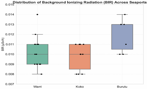
Background ionizing radiation (BIR) in seaport environments contributes to public radiological exposure, yet few studies have quantified this risk in Nigerian ports. This study assessed BIR, annual effective dose equivalent (AEDE), and excess lifetime cancer risk (ELCR) across Warri, Koko, and Burutu seaports. Field measurements were collected at 15, 10, and 7 locations per port, respectively. Descriptive analysis revealed mean BIR values of 0.010 ± 0.002 µSvh⁻¹ (Warri), 0.009 ± 0.001 µSvh⁻¹ (Koko), and 0.012 ± 0.002 µSvh⁻¹ (Burutu), with corresponding AEDE estimates well below the 1 mSvy⁻¹ public exposure limit. Mean ELCR values ranged from 0.206 × 10⁻³ (Koko) to 0.251 × 10⁻³ (Burutu), approaching the UNSCEAR reference level of 0.29 × 10⁻³. Burutu exhibited the highest ELCR, likely due to localized sediment retention zones and port-specific operational features, despite its small size and limited infrastructure. Monte Carlo simulations incorporating instrument uncertainty confirmed the robustness of ELCR estimates, while spatial mapping highlighted micro-zonal hotspots consistent with measured values. Comparison with Onne Port indicated substantially lower ELCRs at the studied seaports, emphasizing the importance of site-specific risk assessments. These findings demonstrate that, although current exposures are within regulatory limits, continued monitoring is recommended, particularly in areas with elevated BIR. The study is limited by its single-season field measurements and small sample size, which may constrain broader generalization. Nonetheless, the combined spatial and probabilistic approach provides a robust baseline radiological data critical for environmental management and public health policy in Nigerian coastal ports.