Comparative Analysis and Performance of Empirical Radiation Models for Estimating Crop Water Requirement in Semi – Arid Region of Northern Environment of Nigeria
Keywords:
Comparative analysis, Empirical models, Statistical models, Agricultural field, Semi-arid region, NigeriaAbstract
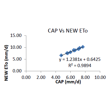
Water's pivotal role in urban planning and hydrological development is crucial for sustainable progress and fostering a green economy. With 97% of the Earth's surface covered by water, its proper utilization in domestic, industrial, and agricultural sectors is paramount. The study is aimed at determining the comparative analysis and performance of empirical radiation models for estimating crop water requirement in semi – arid region of northern environment of NigeriaIn a recent study, the comparison of empirical radiation equations with the Food and Agricultural Organization's Penman-Monteith 56 model, renowned for its efficacy in modeling reference evapotranspiration across various climatic zones, revealed insightful findings. The analysis highlighted the efficacy of empirical models in estimating reference evapotranspiration in semi-arid and arid regions. Notably, in the comparison between the FAO 56 PM model and newer models, such as the Stephen-Stewart (S-S) and the new ETo model, significant differences in performance were observed. For instance, in Kukawa, the R² coefficient was 31.98% for the FAO 56 PM model compared to 99.96% for the S-S and new ETo models. Similarly, the comparison yielded R² values of 31.98% and 98.46%, respectively, against the new model. In Jada, the comparison showcased varying levels of success with different models. The FAO 56 PM model achieved a success rate of 51.3%, while the S-S model scored 99.99% in comparison. Additionally Caprio models demonstrated R² values of 81.41% and 99.74%, respectively, against the new model. These findings underscore the importance of selecting appropriate models for estimating reference evapotranspiration, especially in arid and semi-arid regions, to enhance the accuracy of hydrological assessments and urban planning initiatives.